🥾 Sealy Tarns and Hooker Valley tracks at Aoraki/Mount Cook
One of the activities I was most excited about doing in New Zealand was a couple of hikes in Aoraki/Mount Cook National Park. There is absolutely no shortage of hikes and nature walks in New Zealand—they are everywhere. We avoided visiting places that would be far from our general direction of travel from north to south on our trip, and Mount Cook fit into our itinerary quite well. Considering the other things we wanted to fit in, planning to visit Mount Cook was easy.
We also did some research into the various hikes around the country, and we didn’t have a lot of time on the trip so weren’t particularly keen on a multi-day hike (so that ruled out the Milford Track). A full-day hike was possible, so we did contemplate doing the Tongariro Alpine Crossing, but gave it a skip because it would really take a full day and we’d have to organise drop-off and pick-up. We decided to leave it for another trip.

The easy Hooker Valley track in Mount Cook seemed like a must-do if we were going to visit the national park, but I looked into the other options there to see if we could squeeze in a more challenging hike. I settled on the Sealy Tarns track, which seemed very worthy of doing even though it’s described as the “Stairway to Heaven” with 2,200 stairs. The track is pretty much just stairs, with an altitude of over 500 metres (1,640 ft). Nick and I are quite fit so I was sure we would have no trouble. Different sources said that hiking the track ranged between 2.5 and 4 hours.
Both hikes were return hikes, so we would come back to the starting point. The starting point of both hikes were in the same area. The plan was to do the Sealy Tarns track first thing, arriving as soon as the park opens, and—factoring in crowds and heat during summer—then do the “easy” Hooker Valley track. If we did the easy track first, we might be way too tired to climb stairs, whereas climbing stairs, followed by climbing back down, and then walking a mostly flat track, would be like active recovery. 😉


It turns out we didn’t have to worry at all about sunshine and heat. It was incredibly cloudy and cold when we arrived at Mount Cook. We made good time, arriving at about 8:45am and getting started with the Sealy Tarns hike immediately. In our bag we had packed some snacks, including cereal bars, crackers, fruit, and salami for protein; ponchos; some spare items of clothing; sunscreen; and of course lots of water. It was forecast to rain at around 2:00pm but we estimated we would be done with both hikes by then.
The Sealy Tarns track was probably one of my favourite hikes I’ve ever done. I think the thing that really got me about it was the beautiful views, and the fact that most every other stair-climbing or inline hike or track is through trees or doesn’t have any kind of view for most of the way up, but on the Sealy Tarns track, everywhere you looked had an incredible view. Granted, it was mostly the same as you went around. But it meant you never really got bored, and you could physically see how far you had walked from your starting point (be it vertically or as the crow flies).


It was only a slightly strenuous hike, and the stairs felt like a huge challenge at first, but the further we went along the track, the easier it felt. I roughly counted the stairs and it seemed that there were a little less than 2,000!

There is a spot about halfway where you can get a very good view, but I figure if you make it that far, and aren’t completely cooked, you may as well make it to the top. The track continues onto the Mueller Hut track but that is a more advanced track—you need to be prepared especially in extreme weather conditions. We weren’t game enough to do that track, and we weren’t too keen on preparing for it with all the other travelling we were doing.
At the top of the Sealy Tarns track are beautiful views of the mountains, and in the distance you may be able to spot some with snow. We were able to see a lot of clouds, and the sky wasn’t completely clear. It would be clear on a good day but I recommend sunscreen regardless of the weather, as you are quite exposed to the elements because you are on the side of a mountain the whole time.


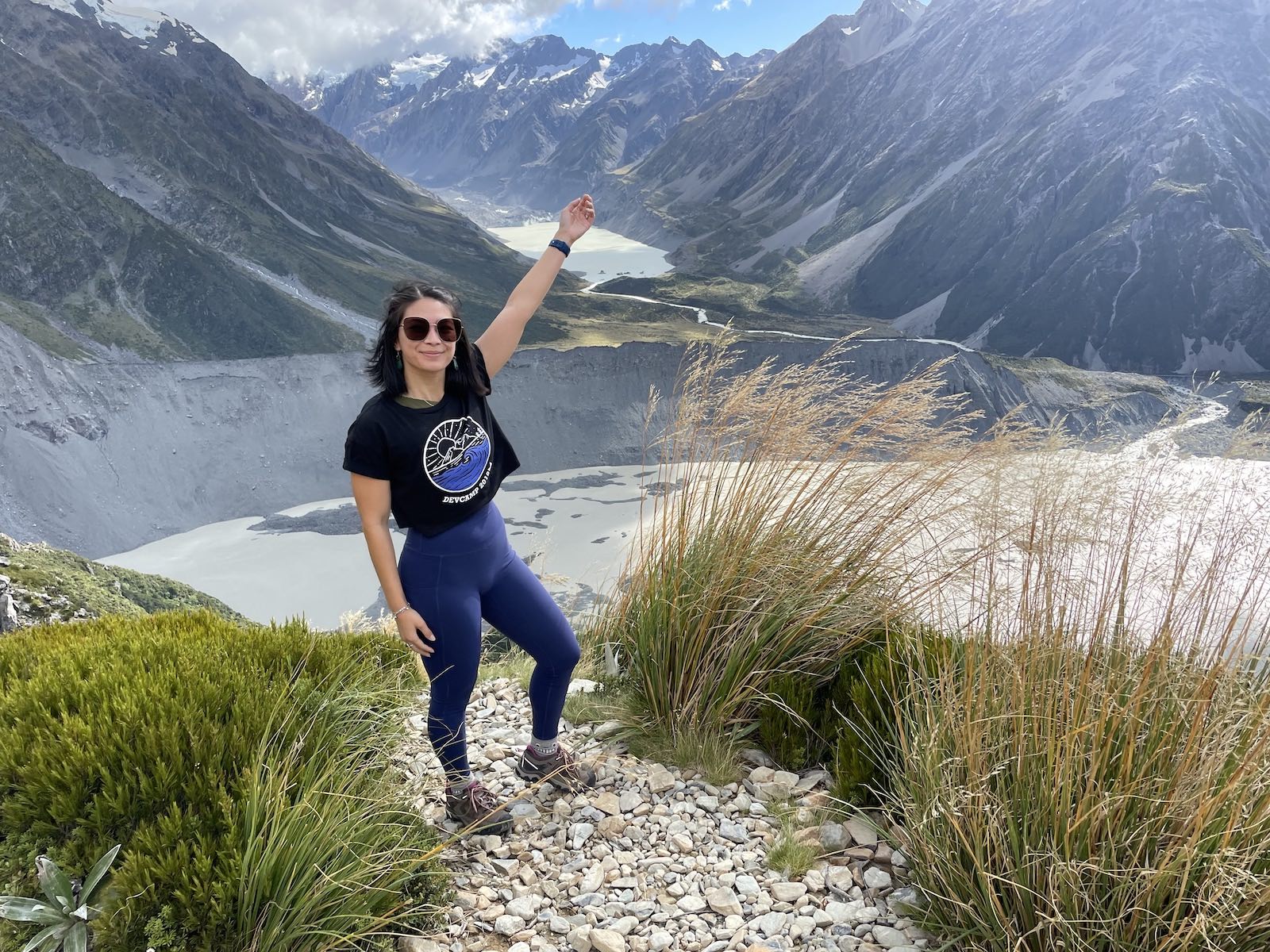
There are some large picnic tables, but there are no other facilities. On the day we went, it was quite cold and windy so we didn’t want to stick around too much. We ate some cereal bars and took some photos before heading back down. It’s definitely tougher on the knees when you head back down so many stairs. In total, it took us almost two-and-a-half hours to do the hike from the starting point and back, including a short break at the top. We obviously had to stop at some points along the hike to catch our breath!

After returning to the start of the hike, we took refuge inside the indoor shelter, and ate some more snacks from our day bag before continuing on the Hooker Valley track. The wind started to pick up a bit while we were on the track, and we moved faster when this happened. The weather had started out looking rather fine, just a little bit cold. We were expecting it to get worse, though.


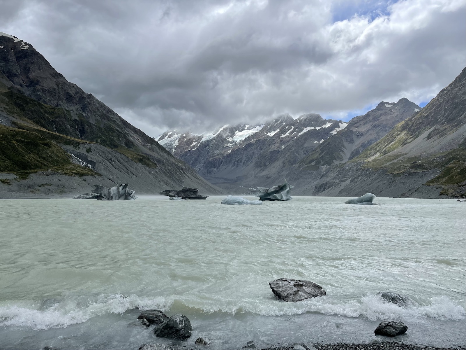
The track crosses three suspension bridges, and apart from a few steps here and there, is otherwise mostly flat with no incline. It’s easy for young children to do if they don’t mind long periods of walking. My only minor disappointment is that it didn’t feel like we could fully enjoy the view from the bridges or take too many photos on it—I believe the wind speed was at least 50–60kmh (31–37mph) and it made it rather uneasy to walk on the bridges so people were moving very fast. I did get this sense of trying to get the hike done quicker to avoid being rained on at 2:00pm.


At the tail end of the hike was access to the edge of a stream of water, and some hikers were enjoying a snack or sitting near the water. There was a sign with a warning that the water was very cold—about 3ºC (37ºF)—which instantly made me think of a refrigerator or freezer, and I thought it mustn’t be too bad to at least touch and put my hand in for a second or two. It was not as cold as I thought, but definitely cold! It felt so fresh.

Unfortunately the rain came an hour earlier than the forecast suggested, so we were were about to start our return when it started drizzling, then quickly picked up speed. It was at that moment that I asked Nick to help me put a poncho on. He had bought a waterproof rain jacket earlier in our trip and didn’t need a poncho, haha. 😛 The wind was being a nuisance and made it difficult to get the poncho on properly. We noticed other people with the same struggle. 😅

It didn’t feel like the poncho did too much, mostly because it kept being blown by the wind on the return. The winds were so strong that I noticed—for myself and other people my size—it was effectively blowing people across the path so they were propelled forward and forced to run. You could also see some of the shrubs and grass on the sides of this boardwalk leaning very far in the same direction because of the wind.

It felt like a hurry to get back, as the rain starting getting worse and everyone wanted to be undercover. Lots of hikers were moving very quickly back to the starting point, while some families with children were still very keen to get photos on the suspension bridge closest to the starting point—despite the blowing winds!

It’s funny how the rain can drench your clothes even though it’s not bucketing with rain, but merely from a light amount of rain over an extended period of time. We were very keen to jump back into the car and drive out of Aoraki/Mount Cook, out of the mountains and into the warm sunshine outside of the park. 🌞
Comments on this post
Megan
Never been hiking and definitely not in good enough shape for it. 😂
But man those views are amazing. I’d love to see something like that in person. Shame the weather got bad near the end though.